


Facebook

Search

Welcome To Roj Bash Kurdistan

Typoon Hayian: 200mph winds gusts up to 235mph
13 posts
• Page 1 of 1
Typoon Hayian: 200mph winds gusts up to 235mph
![]() Author: Anthea » Wed Nov 06, 2013 9:56 pm
Author: Anthea » Wed Nov 06, 2013 9:56 pm
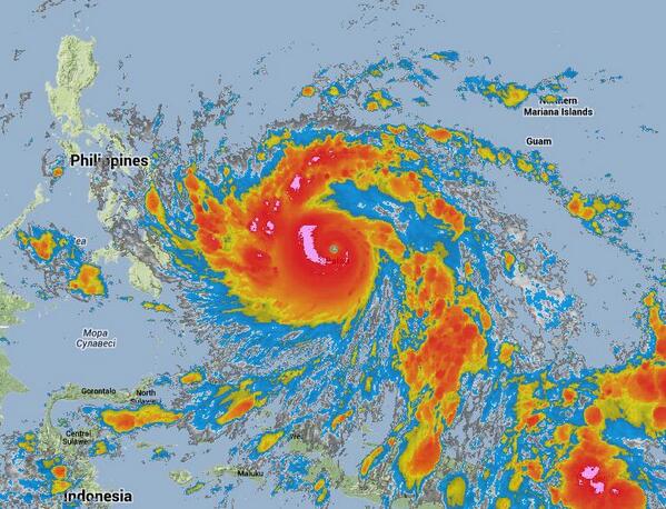
Landfall in Philippines on Friday - unsure if typhoon will have gained much more power by Friday - thousands could be at risk
Last edited by Anthea on Fri Nov 08, 2013 3:21 pm, edited 3 times in total.
My Name Is KURDISTAN And I Will Be FREE
-

Anthea - Shaswar

- Donator

- Posts: 31601
- Images: 1151
- Joined: Thu Oct 18, 2012 2:13 pm
- Location: Sitting in front of computer
- Highscores: 3
- Arcade winning challenges: 6
- Has thanked: 6019 times
- Been thanked: 746 times
- Nationality: Kurd by heart
Re: Typoon Hayian winds 175mph gusts 210mph
![]() Author: Anthea » Thu Nov 07, 2013 1:01 am
Author: Anthea » Thu Nov 07, 2013 1:01 am

A major super typhoon with winds gusting more than 200mph has emerged out of the NW Pacific and is on track to cross the Philippines at the end of this week. With 175 mph sustained maximum winds this is the most powerful storm this year and, were it an Atlantic Hurricane, it would be about the most powerful on record. Although it will weaken slightly when it crosses land, it is still an exceptionally dangerous storm and a great threat because the Philippines is a densely populated country and, while the capital Manila will not receive a direct hit, some 10 million people in Luzon are in the area predicted for Haiyan to make first landfall. The storm is then predicted to track rapidly across to Vietnam where it will arrive on Sunday, possibly still as a strong typhoon.
My Name Is KURDISTAN And I Will Be FREE
-
Anthea - Shaswar
- Donator
- Posts: 31601
- Images: 1151
- Joined: Thu Oct 18, 2012 2:13 pm
- Location: Sitting in front of computer
- Highscores: 3
- Arcade winning challenges: 6
- Has thanked: 6019 times
- Been thanked: 746 times
- Nationality: Kurd by heart
Re: Typoon Hayian winds 175mph gusts 210mph
![]() Author: Anthea » Thu Nov 07, 2013 1:13 am
Author: Anthea » Thu Nov 07, 2013 1:13 am
Super Typhoon Haiyan continues to slowly intensify as it nears the Republic of Palau. The eye of Haiyan was last located approximately 160km east northeast of Palau or about 270km southwest of Yap. Maximum sustained winds have increased to 250kph with gusts of up to 305kph. STY Haiyan is moving westward at 30kph.
For Super Typhoon Haiyan Updates:
https://weatherngayon.wordpress.com/201 ... -update-5/
For Super Typhoon Haiyan Updates:
https://weatherngayon.wordpress.com/201 ... -update-5/
My Name Is KURDISTAN And I Will Be FREE
-
Anthea - Shaswar
- Donator
- Posts: 31601
- Images: 1151
- Joined: Thu Oct 18, 2012 2:13 pm
- Location: Sitting in front of computer
- Highscores: 3
- Arcade winning challenges: 6
- Has thanked: 6019 times
- Been thanked: 746 times
- Nationality: Kurd by heart
Re: Typoon Hayian winds 175mph gusts 210mph
![]() Author: Anthea » Thu Nov 07, 2013 2:41 pm
Author: Anthea » Thu Nov 07, 2013 2:41 pm
Manila Typhoon Center Update (November 07, 2013 at 10:10PM)
Ive never seen a storm this intense…. PAGASA 215 KPH, JMA 230 KPH… JTWC 305 KPH!!!
To my folk in Samar, Leyte, Biliran and everyone in the path. Go to a CONCRETE STRUCTURE IF YOU CAN! All other structures will be OBLITERATED!
Lord God, keep everyone safe. Send your angels to protect everyone.
ManilaTC Admin
Source: Manila Typhoon Center
https://weatherngayon.wordpress.com/201 ... at-1010pm/
Anthea: I feel ashamed when I think of all the fuss and publicity that there was recently about the storm in UK with gusts of 90mph - I cannot even begin to think of how these poor people feel
My Name Is KURDISTAN And I Will Be FREE
-
Anthea - Shaswar
- Donator
- Posts: 31601
- Images: 1151
- Joined: Thu Oct 18, 2012 2:13 pm
- Location: Sitting in front of computer
- Highscores: 3
- Arcade winning challenges: 6
- Has thanked: 6019 times
- Been thanked: 746 times
- Nationality: Kurd by heart
Re: Typoon Hayian winds 175mph gusts 210mph
![]() Author: Anthea » Thu Nov 07, 2013 3:56 pm
Author: Anthea » Thu Nov 07, 2013 3:56 pm
BBC News Asia
"Anthea: Even the BBC has noticed Typoon Hayian - I thought they would eventually "
Authorities in the Philippines are bracing for the arrival of Typhoon Haiyan, which is expected to strike central parts of the country on Friday. The category five storm is moving towards the South East Asian nation with winds of up to 278 km/h (173mph). UPDATE winds 305 km/h (around 200mph).
Haiyan - known as Yolanda in the Philippines - is the strongest storm to hit the Pacific this year.
Schools and offices have already been closed in the region and thousands of people are being evacuated.
Relief packages
Typhoon Haiyan is expected to make landfall at around 09:00 local (01:00 GMT) on Friday between Samar and Leyte, two of the Visayan Islands in central Philippines.
It is then forecast to move over to the South China Sea north of Palawan Island on Saturday, meteorologists say.
In its path are areas already struggling to recover from a 7.3-magnitude earthquake last month, including the worst-hit island of Bohol.
Around 5,000 people are still living in tents in Bohol after losing their homes in the quake, which killed more than 200 people.
The military says its transporting food packages and relief goods to remote communities, and has helicopters on stand-by. Ferry operations have already been suspended and fishing boats ordered back to port.
Thousands of people from villages at risk have been evacuated across several provinces, while schools and offices have shut.
Some areas are already experiencing strong winds and heavy rains, according to Ben Evardone, a member of Congress from Eastern Samar province.
"I have issued a call to prepare for the worst," he told Reuters news agency.
"We have mobilised all LGUs (local government units) and all resources for any contingency. There were already forced and pre-emptive evacuations in some danger areas," he said.
Meteorologists in the Philippines warned that Haiyan could be as devastating as Typhoon Bopha in 2012.
Bopha devastated parts of the southern Philippines, leaving at least 1,000 people dead and causing more than $1bn (£620m) in damage.
"This is a very dangerous typhoon, local officials know where the vulnerable areas are and have given instructions on evacuations," state weather forecaster Glaiza Escullar told AFP.
"There are not too many mountains on its path to deflect the force of impact, making it more dangerous."
It is the 25th typhoon to enter Philippine territory this year.
Pascal Canning from Maasin City, in Southern Leyte, says all schools have been shut in his area and some residents have left their homes.
"Lots of families in not-so-stable dwellings are either moving in with relatives, or to the evacuation centres. Some of our employees will sleep on our premises tonight."
"The biggest worry is the possibility of mudslides... There is an eerie feeling of anticipation amongst us: excited but scared, because at this time there is total calm that we know will not last."
Link & Video:
http://www.bbc.co.uk/news/world-asia-24846813
My Name Is KURDISTAN And I Will Be FREE
-
Anthea - Shaswar
- Donator
- Posts: 31601
- Images: 1151
- Joined: Thu Oct 18, 2012 2:13 pm
- Location: Sitting in front of computer
- Highscores: 3
- Arcade winning challenges: 6
- Has thanked: 6019 times
- Been thanked: 746 times
- Nationality: Kurd by heart
Re: BBC report on Typoon Hayian: 175mph gusts 210mph
![]() Author: Anthea » Thu Nov 07, 2013 11:27 pm
Author: Anthea » Thu Nov 07, 2013 11:27 pm
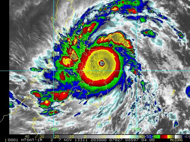
Reports that satellite estimates are showing 858mb pressure at the center of Typhoon Haiyan! That would be a record
Super Typhoon Haiyan, one of strongest storms ever, hits central Philippines
CNN link
http://edition.cnn.com/2013/11/07/world ... ?hpt=hp_t1
Super Typhoon Haiyan, one of strongest storms ever, hits central Philippines
CNN link
http://edition.cnn.com/2013/11/07/world ... ?hpt=hp_t1
My Name Is KURDISTAN And I Will Be FREE
-
Anthea - Shaswar
- Donator
- Posts: 31601
- Images: 1151
- Joined: Thu Oct 18, 2012 2:13 pm
- Location: Sitting in front of computer
- Highscores: 3
- Arcade winning challenges: 6
- Has thanked: 6019 times
- Been thanked: 746 times
- Nationality: Kurd by heart
Re: BBC report on Typoon Hayian: 175mph gusts 210mph
![]() Author: Anthea » Thu Nov 07, 2013 11:30 pm
Author: Anthea » Thu Nov 07, 2013 11:30 pm
(CNN) -- Super Typhoon Haiyan, one of the strongest tropical cyclones ever observed, made landfall Friday morning in the Philippines, the country's weather service reported.
Thousands of people in vulnerable areas of the central Philippines were evacuated as the monster storm spun toward the country.
With sustained winds of 315 kph (195 mph) and gusts as strong as 380 kph (235 mph), Haiyan churned across the Western Pacific into the Philippines.
Its wind strength makes it equivalent to an exceptionally strong Category 5 hurricane.
Haiyan will move over the many islands of the central Philippines over the next 18 hours before exiting into the South China Sea overnight Friday into Saturday. Haiyan will weaken slightly as the storm crosses land, but forecasters with the Philippine weather agency, Pagasa, predict that it will maintain super typhoon intensity throughout its passage of the islands.
The storm, known as Yolanda in the Philippines, is so large in diameter that clouds from it are affecting two-thirds of the country, which extends over 1,850 kilometers (1,150 miles).
Authorities in the region had moved more than 3,800 people to evacuation centers by late Thursday, Maj. Reynaldo Balido of the Philippine Office of Civil Defense said.
Most of those relocated live in Tacloban City, which sits on the coast of the island of Leyte and has a population of more than 200,000.
iReport: Heavy rains as Philippines braces for typhoon
In a speech Thursday, President Benigno S. Aquino III warned residents of the "calamity our countrymen will face in these coming days."
"Let me repeat myself: This is a very real danger, and we can mitigate and lessen its effects if we use the information available to prepare," he said.
The government has three C-130 cargo aircraft ready to respond, as well as 32 planes and helicopters from the air force, the president said.
Officials have placed relief supplies in the areas that are expected to get hit, Aquino said.
"The effects of this storm can be eased through solidarity," he said.
Earthquake survivors vulnerable
As it moves across heavily populated areas of the central Philippines, Haiyan's high winds and torrential rain are expected to affect more than 25 million people. The storm system had a diameter of about 800 kilometers (500 miles) as of Friday.
Pagasa warned more than 30 provinces across the country Thursday to be prepared for possible flash floods and landslides.
Schools in many areas canceled classes, emergency services were put on high alert, and airlines canceled flights.
Some of the most vulnerable people are those living in makeshift shelters on the central Philippine island of Bohol.
Last month, a 7.1-magnitude earthquake hit the island, which lies close to the typhoon's predicted path. The quake killed at least 222 people, injured nearly 1,000 and displaced about 350,000, according to authorities.
Beach resort threatened
Another island in the storm's likely trajectory is the popular beach resort of Boracay. Some tourists there were cutting their vacations short to get away from the possible danger.
Ross Evans, an aviation professional from Florida, said there was "a definite urgency and panic" among the long lines of holidaymakers waiting for boats to get off Boracay on Thursday.
Speaking by phone before his flight to Manila took off, he said he felt "horrible" for those who may end up stuck in the storm's path.
Evans said he and his travel companions, who are leaving the Philippines two days earlier than planned, "feel very fortunate to have the ability to make arrangements to be safe."
Situated near an area of the Pacific Ocean where tropical cyclones form, the Philippines regularly suffers severe storm damage.
An average of 20 typhoons hit the archipelagic nation every year, and several of those cause serious damage.
In December, Typhoon Bopha wreaked widespread devastation on the southern Philippine island of Mindanao. The storm, the most powerful to hit the country that year, is estimated to have killed as many as 1,900 people.
My Name Is KURDISTAN And I Will Be FREE
-
Anthea - Shaswar
- Donator
- Posts: 31601
- Images: 1151
- Joined: Thu Oct 18, 2012 2:13 pm
- Location: Sitting in front of computer
- Highscores: 3
- Arcade winning challenges: 6
- Has thanked: 6019 times
- Been thanked: 746 times
- Nationality: Kurd by heart
Re: BBC report on Typoon Hayian: 175mph gusts 210mph
![]() Author: Anthea » Thu Nov 07, 2013 11:41 pm
Author: Anthea » Thu Nov 07, 2013 11:41 pm
The strongest typhoon that reached landfall in recorded history. This is really not a good thing. Let pray..
My Name Is KURDISTAN And I Will Be FREE
-
Anthea - Shaswar
- Donator
- Posts: 31601
- Images: 1151
- Joined: Thu Oct 18, 2012 2:13 pm
- Location: Sitting in front of computer
- Highscores: 3
- Arcade winning challenges: 6
- Has thanked: 6019 times
- Been thanked: 746 times
- Nationality: Kurd by heart
Re: BBC report on Typoon Hayian: 175mph gusts 210mph
![]() Author: Anthea » Fri Nov 08, 2013 12:38 am
Author: Anthea » Fri Nov 08, 2013 12:38 am

My Name Is KURDISTAN And I Will Be FREE
-
Anthea - Shaswar
- Donator
- Posts: 31601
- Images: 1151
- Joined: Thu Oct 18, 2012 2:13 pm
- Location: Sitting in front of computer
- Highscores: 3
- Arcade winning challenges: 6
- Has thanked: 6019 times
- Been thanked: 746 times
- Nationality: Kurd by heart
Re: BBC report on Typoon Hayian: 175mph gusts 210mph
![]() Author: Anthea » Fri Nov 08, 2013 1:08 am
Author: Anthea » Fri Nov 08, 2013 1:08 am
Sustained winds of 195 mph (313 kph)!
Just broke all scientific intensity scales gusts of 235mph (380km/h)
Lucky I do not live there - we had little wind here few days ago - really heavy news coverage - this storm is almost unknown outside the Philippines
Somewhere under there there are people
Just broke all scientific intensity scales gusts of 235mph (380km/h)
Lucky I do not live there - we had little wind here few days ago - really heavy news coverage - this storm is almost unknown outside the Philippines
Somewhere under there there are people
My Name Is KURDISTAN And I Will Be FREE
-
Anthea - Shaswar
- Donator
- Posts: 31601
- Images: 1151
- Joined: Thu Oct 18, 2012 2:13 pm
- Location: Sitting in front of computer
- Highscores: 3
- Arcade winning challenges: 6
- Has thanked: 6019 times
- Been thanked: 746 times
- Nationality: Kurd by heart
Re: BBC report on Typoon Hayian: 175mph gusts 210mph
![]() Author: Anthea » Fri Nov 08, 2013 1:54 pm
Author: Anthea » Fri Nov 08, 2013 1:54 pm
Philippines typhoon Haiyan: One million displaced

Typhoon Haiyan, the world's strongest storm of the year, has made landfall in the Philippines with winds of up to 235 km/h (146mph).
Reports say up to a million people have been forced to leave their homes.
Link to Video:
http://www.bbc.co.uk/news/world-asia-24863122
Typhoon Haiyan, the world's strongest storm of the year, has made landfall in the Philippines with winds of up to 235 km/h (146mph).
Reports say up to a million people have been forced to leave their homes.
Link to Video:
http://www.bbc.co.uk/news/world-asia-24863122
My Name Is KURDISTAN And I Will Be FREE
-
Anthea - Shaswar
- Donator
- Posts: 31601
- Images: 1151
- Joined: Thu Oct 18, 2012 2:13 pm
- Location: Sitting in front of computer
- Highscores: 3
- Arcade winning challenges: 6
- Has thanked: 6019 times
- Been thanked: 746 times
- Nationality: Kurd by heart
Typoon Hayian: 200mph winds gusts up to 235mph
![]() Author: Anthea » Fri Nov 08, 2013 3:19 pm
Author: Anthea » Fri Nov 08, 2013 3:19 pm
Typhoon Haiyan: Most powerful storm to ever hit land batters Philippines with 200mph winds. Based on satellite images meteorologists have said the super-typhoon could be the most powerful storm ever to make landfall on earth

Typhoon Haiyan, one of the most powerful storms ever recorded, is battering the central Philippines bringing with it sustained winds of nearly 200mph and leaving a trail of devastation in its wake.
Click here or "view gallery" to see the Typhoon Haiyan in pictures
Based on satellite images meteorologists have said the super-typhoon could be the most powerful storm ever to make landfall.
The category-5 super typhoon is currently sweeping through the Philippines powered by fearsome winds and forcing thousands to flee to safer ground.
Forecasters have warned of potentially catastrophic damage in a region already struggling to recover from an earthquake.
At least four people have already died in the storm which has an estimated 25 million people in its path.
The initial estimated wind speeds for landfall of 149mph are 24mph stronger than those of Hurricane Katrina - one of the deadliest storms in history which killed an estimated 1,833 people and caused billions of dollars worth of damage.
The US Navy's Joint Typhoon Warning Centre in Hawaii said Haiyan's maximum sustained winds were 199mph, with gusts up to 235mph.
According to Associated Press telephone lines appeared down as it was difficult to get through to the landfall site 405 miles south east of Manila where Typhoon Haiyan roared into the southern tip of Samar island before barrelling on to Leyte Island.
Weather forecaster Gener Quitlong said the typhoon was not losing much of its strength because there is no large land mass to slow it down since the region is comprised of islands with no tall mountains.
Oxfam said today they were ready to respond to the impact of the super-typhoon.
Felipe Ramiro, acting country director of Oxfam in the Philippines said: “Initial reports from the ground indicate that the provinces of Samar and Leyte in the Visayas region are the hardest hit. Electricity in these areas has been cut off and communication has been difficult. Flights to these provinces and other areas have also been cancelled.”

“As of early afternoon today, around 42,000 families or 210,000 individuals have been affected and are staying in 562 evacuation centres in 22 provinces, according to the National Disaster Risk Reduction and Management Council.”
“Oxfam’s assessment teams will be dispatched to assess the situation of these areas. Oxfam is ready to respond to the emergency should the government need it.”
Ramiro adds: “We hope to know more in the coming hours. The Oxfam teams will be dispatched starting tomorrow, especially to areas which are at risk from hazards like flooding and storm surges and may not be able to bounce back from disaster quickly because of poverty.”
Dr Steven Godby, an expert in disaster management at Nottingham Trent University said agencies in the country may struggle to cope with this latest disaster: “Successive emergencies in the Philippines, which began with an outbreak of fighting in Zamboanga City and Basilan on 9 September and the 7.2 magnitude Bohol earthquake on 15 October, mean that the response capacities of many agencies in the country are overstretched. Given the potential magnitude of the typhoon’s impact, additional ‘surge’ support from the international community may be required."
Haiyan is already the strongest typhoon on earth this year and may be among the strongest storms ever recorded on earth. It's central pressure is reported to be somewhere below 900mb which puts it comfortably among the 20 most powerful storms ever.
Rain will also be a potentially devastating consequence of the storm with between eight and 12 inches of expected across a wide area.
Southern Leyte governor Roger Mercado told AP that 31,000 people were evacuated in his landslide-prone mountainous province before the super typhoon struck, knocking out power, setting off small landslides that blocked roads in rural areas, uprooting trees and ripping roofs off houses around his residence.
Full Article - Pictures - Videos:
http://www.independent.co.uk/news/world ... 26719.html
Typhoon Haiyan, one of the most powerful storms ever recorded, is battering the central Philippines bringing with it sustained winds of nearly 200mph and leaving a trail of devastation in its wake.
Click here or "view gallery" to see the Typhoon Haiyan in pictures
Based on satellite images meteorologists have said the super-typhoon could be the most powerful storm ever to make landfall.
The category-5 super typhoon is currently sweeping through the Philippines powered by fearsome winds and forcing thousands to flee to safer ground.
Forecasters have warned of potentially catastrophic damage in a region already struggling to recover from an earthquake.
At least four people have already died in the storm which has an estimated 25 million people in its path.
The initial estimated wind speeds for landfall of 149mph are 24mph stronger than those of Hurricane Katrina - one of the deadliest storms in history which killed an estimated 1,833 people and caused billions of dollars worth of damage.
The US Navy's Joint Typhoon Warning Centre in Hawaii said Haiyan's maximum sustained winds were 199mph, with gusts up to 235mph.
According to Associated Press telephone lines appeared down as it was difficult to get through to the landfall site 405 miles south east of Manila where Typhoon Haiyan roared into the southern tip of Samar island before barrelling on to Leyte Island.
Weather forecaster Gener Quitlong said the typhoon was not losing much of its strength because there is no large land mass to slow it down since the region is comprised of islands with no tall mountains.
Oxfam said today they were ready to respond to the impact of the super-typhoon.
Felipe Ramiro, acting country director of Oxfam in the Philippines said: “Initial reports from the ground indicate that the provinces of Samar and Leyte in the Visayas region are the hardest hit. Electricity in these areas has been cut off and communication has been difficult. Flights to these provinces and other areas have also been cancelled.”
“As of early afternoon today, around 42,000 families or 210,000 individuals have been affected and are staying in 562 evacuation centres in 22 provinces, according to the National Disaster Risk Reduction and Management Council.”
“Oxfam’s assessment teams will be dispatched to assess the situation of these areas. Oxfam is ready to respond to the emergency should the government need it.”
Ramiro adds: “We hope to know more in the coming hours. The Oxfam teams will be dispatched starting tomorrow, especially to areas which are at risk from hazards like flooding and storm surges and may not be able to bounce back from disaster quickly because of poverty.”
Dr Steven Godby, an expert in disaster management at Nottingham Trent University said agencies in the country may struggle to cope with this latest disaster: “Successive emergencies in the Philippines, which began with an outbreak of fighting in Zamboanga City and Basilan on 9 September and the 7.2 magnitude Bohol earthquake on 15 October, mean that the response capacities of many agencies in the country are overstretched. Given the potential magnitude of the typhoon’s impact, additional ‘surge’ support from the international community may be required."
Haiyan is already the strongest typhoon on earth this year and may be among the strongest storms ever recorded on earth. It's central pressure is reported to be somewhere below 900mb which puts it comfortably among the 20 most powerful storms ever.
Rain will also be a potentially devastating consequence of the storm with between eight and 12 inches of expected across a wide area.
Southern Leyte governor Roger Mercado told AP that 31,000 people were evacuated in his landslide-prone mountainous province before the super typhoon struck, knocking out power, setting off small landslides that blocked roads in rural areas, uprooting trees and ripping roofs off houses around his residence.
Full Article - Pictures - Videos:
http://www.independent.co.uk/news/world ... 26719.html
My Name Is KURDISTAN And I Will Be FREE
-
Anthea - Shaswar
- Donator
- Posts: 31601
- Images: 1151
- Joined: Thu Oct 18, 2012 2:13 pm
- Location: Sitting in front of computer
- Highscores: 3
- Arcade winning challenges: 6
- Has thanked: 6019 times
- Been thanked: 746 times
- Nationality: Kurd by heart
Re: Typoon Hayian: 200mph winds gusts up to 235mph
![]() Author: Anthea » Fri Nov 08, 2013 3:38 pm
Author: Anthea » Fri Nov 08, 2013 3:38 pm
My interest in Typoon Hayiran started for me when - at Wed Nov 06, 2013 9:56 pm - I saw the picture below on a UK weather website
Landfall in Philippines on Friday - unsure if typhoon will have gained much more power by Friday - thousands could be at risk
I looked all over the news sites and could not find any information anywhere - remembering all the information there had been about the recent storm that hit England - I thought surely someone else somewhere knew what was happening - I was determined that the storm should not go unnoticed hence my coverage - I notice that all major news sites now have coverage
I did not post the messages I received because they were far too distressing - people praying and thinking they were going to die - unbelieving that wind could be so strong - fortunately very few people were actually injured as those most at risk were evacuated to places of safety
I leave this topic with the message I picked up from the Philippines Typhoon Centre:
"Lord God keep everyone safe - send your angels to protect everyone"
My Name Is KURDISTAN And I Will Be FREE
-
Anthea - Shaswar
- Donator
- Posts: 31601
- Images: 1151
- Joined: Thu Oct 18, 2012 2:13 pm
- Location: Sitting in front of computer
- Highscores: 3
- Arcade winning challenges: 6
- Has thanked: 6019 times
- Been thanked: 746 times
- Nationality: Kurd by heart
13 posts
• Page 1 of 1
Who is online
Registered users: Bing [Bot]